Please follow all of the latest Hurricane Lee updates on the National Hurricane Center Website.
Updated 5:00 pm EDT
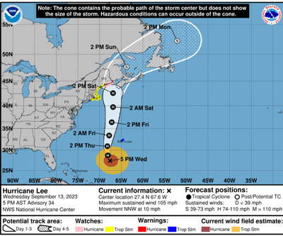
As of 5:00 pm EDT on September 13, Hurricane Lee was downgraded to a Category 2, with sustained winds of 105 mph.
There is an increasing risk of wind, coastal flooding, and rain impacts from Lee in portions of New England and Atlantic Canada beginning on Friday and continuing through the weekend. Watches will likely be required for portions of these areas later today or tonight. Due to Lee's large size, hazards will extend well away from the center, and there is still no clear sense of exactly where the center of the storm will impact the coast.
Here are the key points from the National Hurricane Center:
- Hurricane conditions, heavy rainfall, and coastal flooding are possible in portions of eastern Maine on Saturday, and a Hurricane Watch has been issued for that area.
- There is the potential for life-threatening storm surge flooding in portions of southeastern Massachusetts, including Cape Cod and Nantucket, late Friday and Saturday, where a Storm Surge Watch has been issued.
- Tropical storm conditions are possible over a large portion of coastal New England, including Cape Cod, Nantucket, Martha’s Vineyard, and Block Island, where a Tropical Storm Watch has been issued.

Storm surge and inland flooding have historically been the number one and two causes of loss of life during hurricanes. Heavy rainfall is anticipated in affected areas and, due to pre-existing saturated conditions from the wet summer in New England, there is a high likelihood of flash flooding and inland flooding, along with coastal flooding.
Morning Update - Wednesday, September 13, 2023
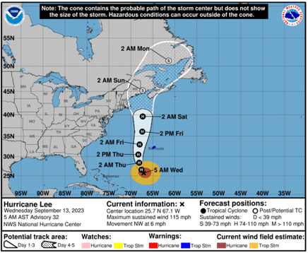
According to the National Hurricane Center, Hurricane Lee remains a major, Category 3 hurricane as it travels in the western Atlantic. The storm has taken a northward turn and will likely run northward parallel to and just east of the US coastline.
The storm is not expected to make landfall until reaching the Maine–Canada border and is forecasted to weaken over the next few days. It’s wind field, however, is expanding and the large size of the storm will extend its hazards well away from the hurricane center – both as it travels and when it reaches the coast.
Coastal areas from Long Island, New York, to Rhode Island, Eastern Massachusetts and north to Maine will likely see tropical storm-force winds and a high risk of major beach erosion and coastal flooding with large surf, waves and rip currents beginning late Friday and continuing into the weekend.

Storm surge and inland flooding have historically been the number one and two causes of loss of life during hurricanes. Heavy rainfall is anticipated in affected areas and, due to pre-existing saturated conditions from the wet summer in New England, there is a high likelihood of flash flooding and inland flooding, along with coastal flooding.
Tracking the Storm and Staying safe
Storm Tracking - Conditions are always susceptible to change, including storm path and intensity. Stay up to date with the latest information from the National Hurricane Center about the storm. Heed all warnings and evacuation orders from your local authorities.
Preparation resources - Hurricanes and tropical storms pose a variety of threats to people and property. Review our Hurricane Preparedness Guide, Disaster Preparedness Kit, and Post Hurricane Checklist for steps you can take before, during, and after the storm. Additional preparation and recovery guides are available in our Hurricane Resources Center.
Key steps to take Before the Storm Arrives:
- Activate your severe weather emergency action plan
- Clear storm and roof drains of debris
- Check roof condition and make any necessary last minute repairs
- Bring in or secure outdoor furniture, signage, planters, and other unsecured items
- Gather and install sandbags or flood protection materials
- Gather critical and important documents
- Monitor the storm and follow local authorities' guidance on evacuation
- Do not drive through flood waters
Business owners should take all necessary precautions and preparation steps to protect their businesses from wind damage and flooding potential.
Homeowners and residents should take all necessary precautionary and preparation steps to stay safe and protect their homes from wind damage and flooding potential. In addition to the steps above, prepare for being away from home for an extended period of time and bring all needed medications and essential items.
Boat and yacht owners located in or near the forecasted path/cone of the storm should start to take preparation steps now and should execute their formal hurricane storm plans. Consider hauling smaller boats and storing your boat in a safe, protected location away from trees, coastal flooding, and tidal surge. Boats in the path or cone of the hurricane should not be left on davits or lifts. Boats remaining in the water should be moved to the most sheltered location possible and secured with extra lines, crossing spring lines, chafe gear, and additional fenders. All non-permanent items should be removed including sails, canvas, fishing gear, bimini-tops, dinghies, portable electronics, etc. All non-removeable items should be secured and lashed.
Marinas and yacht clubs located in or near the forecasted path/cone of the storm should start to take preparation steps now. Winds, surge, and flooding from the storm are expected to cause significant impacts for hundreds of miles outward from the center. Yacht Clubs are invited to download our Sailing Organization Hurricane Preparation Activation Template.
After the Storm & Claims Reporting
The Hurricane Response Team at Risk Strategies is On-Watch and Ready to Help. Teams at Risk Strategies are prepared and ready to assist you before, during and after the storm. If you have any questions regarding your insurance policy or preparation steps, please contact your Risk Strategies Account Team member directly, or reach our Safety & Loss Control Team at safety@risk-strategies.com.
How to Report a Claim. Our claims experts work as your advocate and help you manage the claim process. The most efficient way to start the claim process is for you to report your claim directly to your insurance carrier using the claim reporting contact information found on your policy or the carrier website. You can also visit our website to access a list of claims reporting contact information by carrier name.
If you are in need of remediation or additional claims assistance, please contact the Risk Strategies' Claims Team at claims@risk-strategies.com.
Staying Safe After the Storm. Hurricane-related hazards do not immediately disappear with the storm clouds. After the storm clears, use generators safely, be careful not to overexert yourself, and do not venture into storm-damaged areas before it is safe and local authorities have given permission. Our post-storm check list provides important recovery reminders.


